


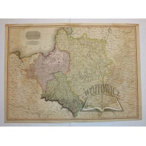
(POLSKA). "Poland".
Staloryt kolor. Drawn under the Direction of Pinkerton by L. Hebert; Neele sculp...". Published... London 1814. By Cadell & Davies ... Format: 50,5 x 60 cm (plansza: 53,5 x 73,5 cm).
Mapa ukazuje podział terytorialny Polski dokonany przez 3-ech zaborców z wyszczególnieniem krain historycznych. Nad mapą listwowo napis: "Pinkerton's Modern Atlas". Ślady niew. zawilg. Stan dobry. Verso czyste.


![Poland car map. Cracow [1945].](https://img1.one.bid/img/6508/1873705_1x.webp?1713823200)
![Poland car map. Cracow [1945].](https://img1.one.bid/img/6508/1873705_2x.webp?1713823200)


![[MAP]. MAP OF POLAND 1 : 500 000. OLSZTYN. [Sheet ] 3. w-wa 1947....](https://img1.one.bid/img/6363/1859794_1x.webp?1713045600)


Nesen skatītās
Piesakies, lai redzētu lotu sarakstu
Iecienītākie
Piesakies, lai redzētu lotu sarakstu