


miedzioryt kolorowany, papier; wymiary w świetle passe-partout 50 x 58,5 cm;
oprawa współczesna - passe-partout, rama, szkło.
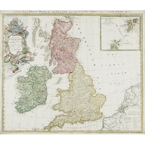
Norymberga, 1729
Z lewej strony u góry kartusz z napisem: „MAGNA / BRITANNIA / complectens / ANGLIAE, SCOTIAE / et / HYBERNIAE REGN. / in suas Prov. et Comitat. / divisa et ex mappis Lon=/ dinensibus designata / per Homannum / A. 1720”. Nad górnym marginesem: „A General Map of GREAT BRITAIN and IRELAND with Part of Holland, Flanders, France de Agreable to modern History / By the Heirs of late Mr Homann, at Nuremberg”. W prawym górnym narożu wydzielona mapka z napisem: „ORCADES INSULAE / borealiores / nec non Insul /
SCHETLANDICAE / secundum eandem mappae / principalis Scalam / exhibitie”.


![Map of Bydgoszcz area [ca] 61x45, [post 1922].](https://img1.one.bid/img/6474/1885259_1x.webp?1714687200)
![Map of Bydgoszcz area [ca] 61x45, [post 1922].](https://img1.one.bid/img/6474/1885259_2x.webp?1714687200)


Nesen skatītās
Piesakies, lai redzētu lotu sarakstu
Iecienītākie
Piesakies, lai redzētu lotu sarakstu