


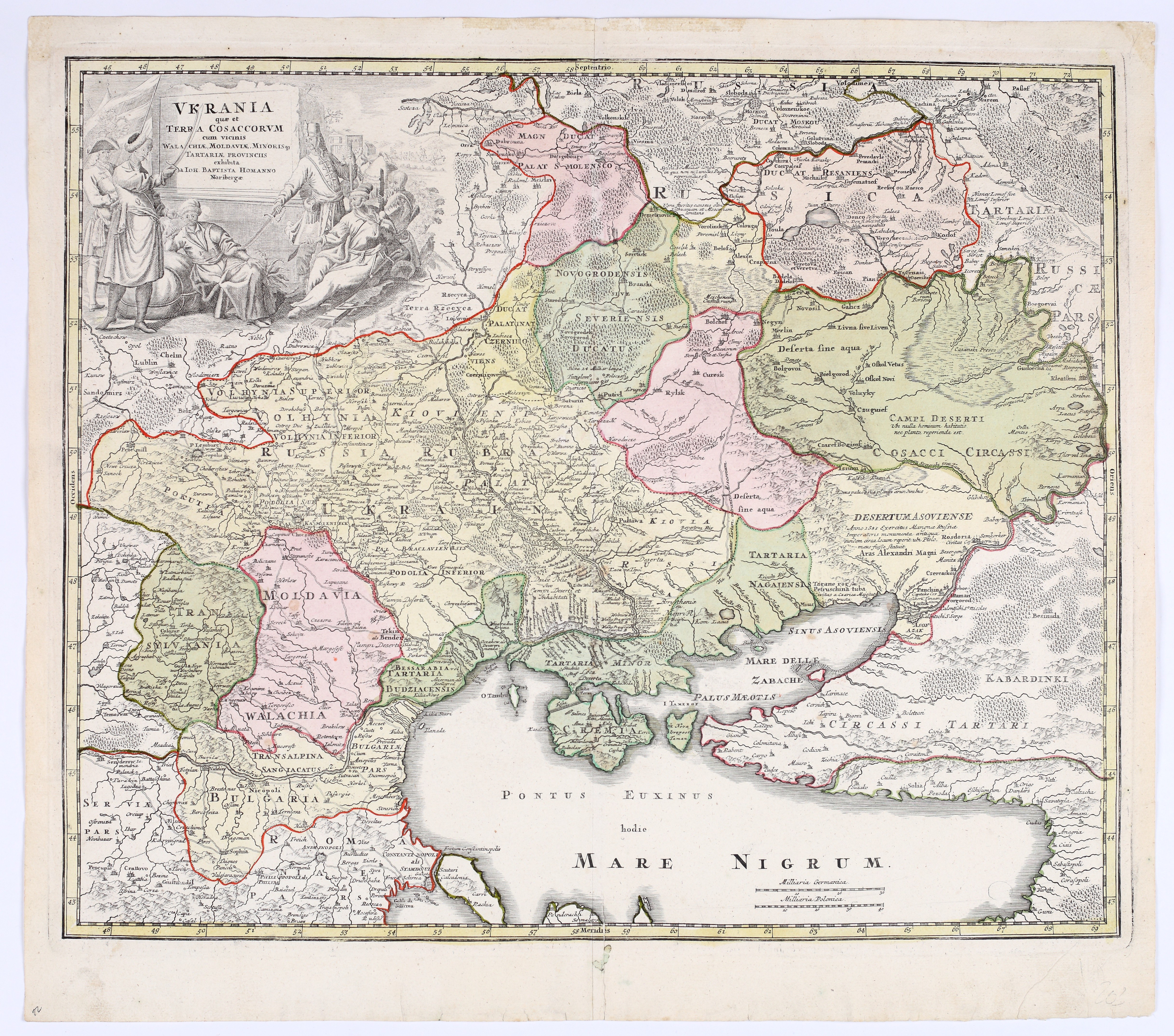
HOMANN, Johann Baptist (1664–1724) — *Ukrania quae et Terra Cosaccorvm*. Nuremberg: Homann’s Heirs, ca. 1745.
Contemporary hand-colored copperplate engraving, paper, 485 × 585 mm, on a sheet measuring 545 × 615 mm. Blank verso. Traces of atlas folding; paper slightly creased on the right side of the fold; margins slightly soiled and creased. Condition 4.
The map “Ukraine, also known as the Land of the Cossacks, together with the neighboring provinces of Wallachia, Moldavia, and Little Tartary” covers the area from Podolia, Volhynia, and the western outskirts of Moscow in the north to the Black Sea, the Crimean Peninsula and the Sea of Azov in the south, and from Poland and Silesia in the west to Circassia and the Kuban region in the east. A richly decorated figurative title cartouche occupies the upper left corner. On the left, two figures in European attire—one wearing a three-cornered hat with a feather, the other in a fur-trimmed coat—hold aloft a rolled-up banner topped with an eagle, while brandishing their raised sabers. Opposite them, on the right, is a group featuring a figure in a turban seated with his back to the viewer and, further away, richly dressed Cossacks or Tatars with sabers, turbans, and beards, set against a backdrop of tents and a fortified building.
The map was originally engraved and published by Homann between 1712 and 1714 and is characteristic of the period of his career when he was rapidly expanding his collection of maps. Homann, an engraver by training, copied the geographical content almost line for line from the first edition of the large map *Carte du Théâtre de la Guerre dans la Pologne,* *Moscovie & Turquie*, published around 1710 in Amsterdam by Visscher as an illustration of the theater of operations during the Great Northern War. Homann translated the place names and brief texts on the map into Latin (though some names, such as “Moscou,” remained in French), and then added a distinctive, beautifully engraved cartouche, whose allegorical depiction has been the subject of various interpretations. The fourth edition was included in atlases published by Homann’s heirs from around 1740 onward, following the loss of the imperial privilege, which was removed from the map. For more on Johann Baptist Homann and his maps of Poland and Silesia, see items 27 and 34.
One of the most famous and sought-after early maps of Ukraine.
Imago Poloniae, K97/4.










Nesen skatītās
Piesakies, lai redzētu lotu sarakstu
Iecienītākie
Piesakies, lai redzētu lotu sarakstu